Can urban vegetation help cool Singapore?
Using urban microclimate modelling, Future Resilient Systems (FRS) researchers show why neighbourhoods heat up differently and how vegetation and wind helps in cooling them down.
Header Image: external page Nirmala Damith Jayawardena
Is urban greenery such as street trees, courtyard greenery, and parks a one-size-fits-all solution for reducing heat in a tropical city like Singapore?
Yuan Chao, Dominique Derome, and Jan Carmeliet use urban microclimate modelling to show why neighbourhoods heat up differently and how vegetation and wind helps in cooling them down
The urban heat island effect, which causes higher temperatures in cities compared to surrounding rural areas, has heightened awareness of the health risks associated with prolonged exposure to extreme urban heat, particularly in places like Singapore. Urban vegetation, like trees, is thought to be an effective to cool cities because they provide shade and release moisture through evaporation, cooling the surrounding environment.
Moreover, placing well-selected plants and trees in wind corridors can enhance their cooling effect. Wind corridors are pathways within a city that channel and enhance airflow. However, the presence of dense canopies in wind corridors can slow down wind and reduce cooling. Trees can also block air currents, reducing cooling in nearby areas, and trap the accumulated heat at night due to reduced radiation from the ground to sky. For instance, in densely built-up areas, wind corridors without trees can become ‘hot air corridors’. This is because the sun heats up dark, non-shaded surfaces like asphalt. This makes it challenging to design cool walkways for pedestrians, requiring a balance between the positive and negative effects of trees.
Since every part of a city has its own unique layout, heat-reduction solutions must be tailored to fit the local context. This means paying close attention to the arrangement of buildings and open spaces. Better strategies are needed to optimise the cooling effect of plants in different city environments, such as: finding the best places for greenery to create shaded areas, improving airflow to remove heat, and creating cooling wind corridors.
From a research perspective, it still remains to be seen whether grouping or spreading out green areas works best, as this is dependent on the surrounding building arrangement and the influence of local weather, like monsoons, and local microclimates.
To address these challenges, researchers developed a step-by-step approach to guide urban greenery design.
Step 1
First, the overall climate of a city is simulated using mesoscale weather models at a spatial resolution of 250 meters. Using this, researchers are able to identify hot spots in the city as well as hot periods during different seasons (e.g. monsoon, inter-monsoon) to be then studied in more detail at a local level.

Credits: Landscape illustration by Freepik, Weather elements by Vecteezy (Modified by Michelle Chan Mei Har)
The next step involves zooming into specific neighbourhoods within the city to study and simulate how the heat affects these areas at the micro-level (down to a spatial resolution of 0.1 meters). This is crucial for resolving local wind patterns, including turbulence. This level of detail also enables the inclusion of important urban elements like shrubs, shading devices, and other features. At this spatial resolution, the models can examine the effects of:
- Wind sheltering and shading by buildings and trees,
- Radiative exchanges between the sun, buildings, streets, trees and sky,
- Heat and moisture storage in materials like pavements and facades,
- Cooling by evapotranspiration from vegetation.

Figure 1. Schematic of the urban microclimate model “urbanMicroclimateFoam” developed by team of Jan Carmeliet (© Carmeliet, J., Derome, D. Nat Rev Phys 6, 2–3, 2024).
Step 2
Next, researchers identify heat stress zones and use indicators like air temperature and the Universal Thermal Climate Index (UTCI) to measure the thermal comfort which takes into account the human physiological response to the thermal environment, specifically: air temperature, humidity, wind and radiation.
Accordingly, heat zones are identified and mapped on a typology map of open spaces like parks, roads, walkways and courtyards.
Step 3
Lastly, new greenery is proposed and tested in simulations based on factors like vegetation coverage and planting layout and how much sky is visible from the ground. The cooling effects of these new designs are compared to the current setup to guide the better use of urban greenery to improve the comfort of residents.

Figure 2. Urban greenery cooling strategies for two scenarios: (a) site with inferior wind environment; (b) site with superior wind environment. Left: current state. Right: improved design. Cooling strategies developed by team of Chao Yuan. Courtesy of L.Q. Zhang.
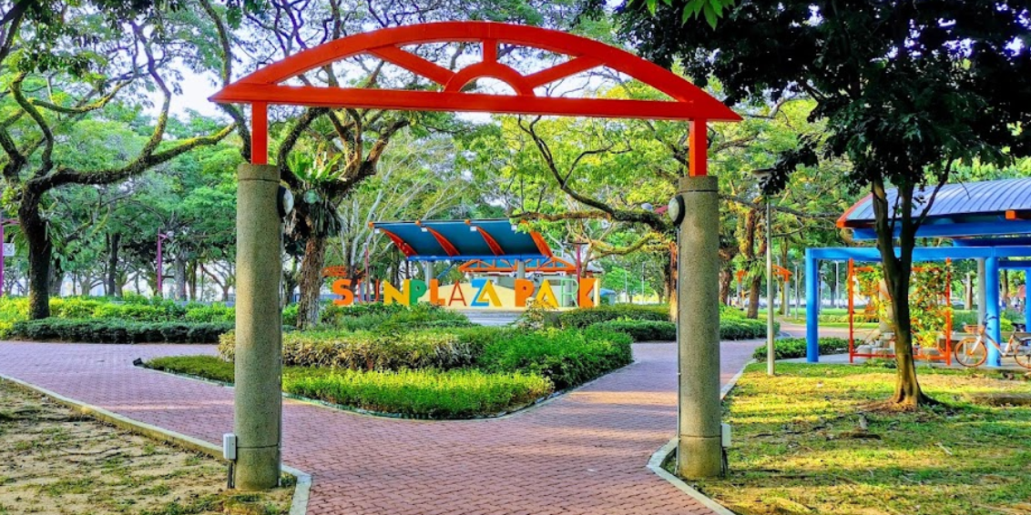
Researchers have analysed different areas of Singapore to examine how air cooling by vegetation depends on factors such as building and/or vegetation density and layout, as well as wind speed and direction. In areas with poor wind flow, it was found that grouping plants to create cool islands in public spaces work best, while in well-ventilated places, placing vegetation where the wind enters the area helps to spread cooling more efficiently (Figure 2). Seasonal changes also play a role in maintaining the strong, year-round cooling effect. Another study focused on Sun Plaza Park (Figure 3), where the air in the park with many trees is found to be 2°C cooler than the nearby built-up area. However, trees in the park also have the effect of blocking the wind, which prevents cool air from spreading to neighbouring buildings. Trees even increase the already high relative humidity by transpiration having a negative effect on thermal comfort. In shaded areas of the park, the thermal comfort was shown to improve by as much as 6 UTCI degrees. In comparison, this cooling effect is much more limited in the park’s open unshaded grass areas.
Finally, once results are gathered, they need to be presented in an interactive and easy-to-understand way to ensure that it is accessible for both city planners and the general public.

Figure 3. The Microclimate Digital Platform - a web-based digital platform to visualize and model urban microclimate simulations to support urban planning in Singapore.
The external page Microclimate Digital Platform (MDP) was developed to address this need. Through this open-access platform, public users are able to assess microclimates at different scales in relation to a multitude of factors, including: urban heat island effect, urban wind, urban anthropogenic heat, solar exposure, as well as heat mitigation measures. This tool is instrumental in enabling urban planners make more data-driven decisions in their integration of vegetation in urban planning to cool cities effectively. By leveraging on the MDP’s advanced modelling techniques, urban planners will be able to better understand its multi-dimensional impact. This empowers them to design greener urban areas that are not only cooler and more enjoyable, but also healthier and more resilient for everyone.
Further Reading
- Access the Microclimate Digital Platform here: https://mdp.frs.ethz.ch/
- Carmeliet, J., Derome, D. How to beat the heat in cities through urban climate modelling. Nat Rev Phys 6, 2–3 (2024). external page https://doi.org/10.1038/s42254-023-00673-1